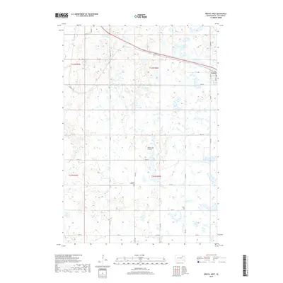
2017 Map of Bristol West
USGS Topo · Published 2017About this map
The glacial upland of the Coteau des Prairies dominates this corner of Day County, defined by a dense network of prairie potholes and wetlands typical of the region. The settlement of Bristol sits at the northeastern edge of the sheet, serving as a primary point of transit where regional roads and rail infrastructure converge. Beyond the town, the landscape is organized by a precise grid of rural routes like Co Rd 35 and Co Rd 26, reflecting the enduring agricultural character of the plains. For those tracing local heritage, the map identifies small, isolated burial grounds including Bethany Evangelical Cem and Sjurson Cem. Drainage for this marshy terrain is provided in part by Mud Cr, which winds through the southwestern sections amidst the countless small basins that pockmark the prairie floor.
Find a feature on this map
23 named features on this map. Tap any name to fly to it.
Don’t see what you’re looking for? This feature index may not catch every label — zoom into the map to look around manually.
Map Details
Editions of this 2017 Bristol West Map
This is the sole edition of this map. No revisions or reprints were ever made.
Other maps of this area

1953 · Milbank
USGS Topo · 1:250,000

1958 · Milbank
USGS Topo · 1:250,000

1958 · Andover
USGS Topo · 1:24,000

1958 · Andover SW
USGS Topo · 1:24,000

1958 · Pierpont
USGS Topo · 1:24,000
1958 · Crandall
USGS Topo · 1:24,000

1973 · Lily
USGS Topo · 1:24,000

1973 · Lynn Lake
USGS Topo · 1:24,000

1973 · Bristol West
USGS Topo · 1:24,000

1973 · Lone Tree Lake
USGS Topo · 1:24,000