
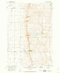
1973 Map of Bristol West
USGS Topo · Published 1976About this map
Bristol Valley defines the topography of this South Dakota landscape, where the Chicago Milwaukee St Paul and Pacific railroad cuts a diagonal line through the northern plains. The small settlement of Bristol sits at the eastern edge of the quadrangle, serving as a focal point for the surrounding rural townships of Andover and Scotland. A series of natural depressions and wetlands are preserved within the National Waterfowl Production Area, contrasting with the orderly grid of section lines and fence rows identified during this 1970s survey. Local landmarks like the Bethany Cem and the Town Hall provide specific points of interest for genealogists and local historians tracking the community's civic and social footprint. The presence of a Gravel Pit and Mud Creek further illustrate the interaction between local industry and the natural drainage patterns of Day County.
Find a feature on this map
13 named features on this map. Tap any name to fly to it.
Don’t see what you’re looking for? This feature index may not catch every label — zoom into the map to look around manually.
Map Details
Editions of this 1973 Bristol West Map
This is the sole edition of this map. No revisions or reprints were ever made.
Other maps of this area

1953 · Milbank
USGS Topo · 1:250,000

1958 · Milbank
USGS Topo · 1:250,000

1958 · Andover
USGS Topo · 1:24,000

1958 · Andover SW
USGS Topo · 1:24,000

1958 · Pierpont
USGS Topo · 1:24,000
1958 · Crandall
USGS Topo · 1:24,000

1973 · Lily
USGS Topo · 1:24,000

1973 · Lynn Lake
USGS Topo · 1:24,000

1973 · Lone Tree Lake
USGS Topo · 1:24,000

1973 · Bristol East
USGS Topo · 1:24,000