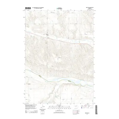
2014 Map of Bristow
USGS Topo · Published 2014About this map
The Niobrara River serves as the primary geographic dividing line on this Nebraska landscape, marking the border between Boyd and Holt counties. To the north, the small village of Bristow is situated near the banks of Ponca Creek, characterized by a grid that includes Depot St and Park St, reflecting its historical layout. Local heritage is anchored by sites like Bristow Cemetery and the Mission Cemetery further north, while the southern portion of the sheet features the community of Paddock and the meandering path of Eagle Creek. The terrain is defined by a series of drainages leading toward the major river valley, with rural infrastructure such as Schaaf Reservoir and a network of section-line roads like Roosevelt Road connecting the scattered homesteads and agricultural tracts of the early 21st century.
Find a feature on this map
27 named features on this map. Tap any name to fly to it.
Don’t see what you’re looking for? This feature index may not catch every label — zoom into the map to look around manually.
Map Details
Editions of this 2014 Bristow Map
This is the sole edition of this map. No revisions or reprints were ever made.
Other maps of this area

1950 · Dorsey NW
USGS Topo · 1:24,000

1950 · Lynch
USGS Topo · 1:24,000

1951 · Bristow
USGS Topo · 1:24,000

1952 · Spencer South
USGS Topo · 1:24,000

1954 · Meek NE
USGS Topo · 1:24,000

1954 · Meek
USGS Topo · 1:24,000

1955 · O'Neill
USGS Topo · 1:250,000

1959 · O'Neill
USGS Topo · 1:250,000

1964 · Gross
USGS Topo · 1:24,000
1964 · Spencer North
USGS Topo · 1:24,000