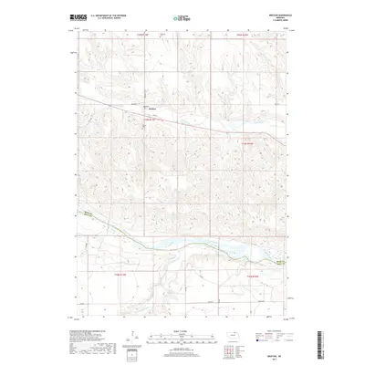
2017 Map of Bristow
USGS Topo · Published 2017About this map
Bristow sits at the heart of this landscape, anchored by its village streets like Depot St and Park St. The town's proximity to Ponca Creek highlights a history of settlement along the waterways of northern Nebraska. To the south, the terrain descends toward the Niobrara River, where the Boyd Co and Holt Co boundary line follows the river's winding path. This area reveals a transition from the agricultural grid of the northern sections to the more complex hydrology of the south, including the small Schaaf Reservoir and the meandering Eagle Creek. Genealogists and local historians can locate established burial grounds such as Bristow Cem and the Mission Cemetery, which serve as permanent records of the early families who inhabited this portion of Paddock and the surrounding countryside.
Find a feature on this map
23 named features on this map. Tap any name to fly to it.
Don’t see what you’re looking for? This feature index may not catch every label — zoom into the map to look around manually.
Map Details
Editions of this 2017 Bristow Map
This is the sole edition of this map. No revisions or reprints were ever made.
Other maps of this area

1950 · Dorsey NW
USGS Topo · 1:24,000

1950 · Lynch
USGS Topo · 1:24,000

1951 · Bristow
USGS Topo · 1:24,000

1952 · Spencer South
USGS Topo · 1:24,000

1954 · Meek NE
USGS Topo · 1:24,000

1954 · Meek
USGS Topo · 1:24,000

1955 · O'Neill
USGS Topo · 1:250,000

1959 · O'Neill
USGS Topo · 1:250,000

1964 · Gross
USGS Topo · 1:24,000
1964 · Spencer North
USGS Topo · 1:24,000