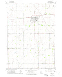
1972 Map of Britt
USGS Topo · Published 1975About this map
Britt serves as the central hub of this northern Iowa landscape, where the intersections of the Chicago Milwaukee St Paul and Pacific and the Chicago and North Western railroads define the town's grid and industrial character. The surrounding countryside in Britt and Erin townships is deeply marked by its water systems, notably the headwaters of the Boone River and its various tributaries, including the Middle Branch Boone River and East Branch Boone River. These waterways, alongside managed infrastructure like Drainage Ditch No 1, illustrate the intensive agricultural modification of the Hancock County prairie. Local landmarks such as the Fairground, located just south of the main settlement, and the Golf Course to the north, point to the community's social centers. Genealogists will find the positions of Evergreen Cem and St Patricks Cem valuable for tracing local family histories within this well-established farming region.
Find a feature on this map
16 named features on this map. Tap any name to fly to it.
Don’t see what you’re looking for? This feature index may not catch every label — zoom into the map to look around manually.
Map Details
Editions of this 1972 Britt Map
This is the sole edition of this map. No revisions or reprints were ever made.
Other maps of this area

1954 · Mason City
USGS Topo · 1:250,000

1954 · Waterloo
USGS Topo · 1:250,000

1955 · Waterloo
USGS Topo · 1:250,000

1957 · Mason City
USGS Topo · 1:250,000

1958 · Mason City
USGS Topo · 1:250,000

1972 · Corwith
USGS Topo · 1:24,000

1972 · Kanawha
USGS Topo · 1:24,000

1972 · Hayfield
USGS Topo · 1:24,000

1972 · Olaf
USGS Topo · 1:24,000

1972 · Crystal Lake
USGS Topo · 1:24,000