
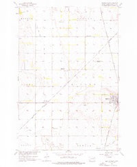
1956 Map of Britton West
USGS Topo · Published 1957About this map
Britton serves as the primary hub of this eastern South Dakota landscape, where the intersection of two major rail lines once shaped the local economy. The town's layout is clearly defined alongside the Chicago Milwaukee St Paul and Pacific and Great Northern railroads, reflecting a period when rail connectivity was vital for agricultural transport in the Missouri River Basin. The surrounding townships of Dayton, Newark, Miller, and Lowell reveal a rural infrastructure in transition, marked by School No 1 and School No 2. Natural drainage is dominated by Crow Creek and several instances of a Flowing Well, illustrating the subterranean water resources of Marshall County during the mid-1950s. Genealogists will find the Britton Cemetery and the settlement at West Britton particularly useful for tracing family roots in this prairie region.
Find a feature on this map
14 named features on this map. Tap any name to fly to it.
Don’t see what you’re looking for? This feature index may not catch every label — zoom into the map to look around manually.
Map Details
Editions of this 1956 Britton West Map
2 editions found
Other maps of this area

1953 · Britton East
USGS Topo · 1:24,000

1953 · Newark SW
USGS Topo · 1:24,000

1953 · Kidder
USGS Topo · 1:24,000

1953 · Newark
USGS Topo · 1:24,000

1953 · Milbank
USGS Topo · 1:250,000

1956 · Newark NW
USGS Topo · 1:24,000

1958 · Milbank
USGS Topo · 1:250,000

1958 · Spain
USGS Topo · 1:24,000

1958 · Britton 4 NW
USGS Topo · 1:24,000
1958 · Amherst
USGS Topo · 1:24,000