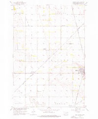
1956 Map of Britton West
USGS Topo · Published 1976About this map
Britton serves as the primary hub of this 1950s Marshall County landscape, situated where the Chicago Milwaukee St Paul and Pacific railroad intersects the local infrastructure. The transition from active rural community life is visible in the presence of School No 1 and School No 2, indicating a shift in educational patterns as smaller schoolhouses were left behind. The land is defined by a systematic network of drainage and water management, featuring several instances of the Flowing Well label and a series of ditches and wells.
Find a feature on this map
23 named features on this map. Tap any name to fly to it.
Don’t see what you’re looking for? This feature index may not catch every label — zoom into the map to look around manually.
Map Details
Editions of this 1956 Britton West Map
2 editions found
Other maps of this area

1953 · Britton East
USGS Topo · 1:24,000

1953 · Newark SW
USGS Topo · 1:24,000

1953 · Kidder
USGS Topo · 1:24,000

1953 · Newark
USGS Topo · 1:24,000

1953 · Milbank
USGS Topo · 1:250,000

1956 · Britton West
USGS Topo · 1:24,000

1956 · Newark NW
USGS Topo · 1:24,000

1958 · Milbank
USGS Topo · 1:250,000

1958 · Spain
USGS Topo · 1:24,000

1958 · Britton 4 NW
USGS Topo · 1:24,000