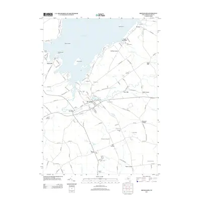
2013 Map of Broadalbin
USGS Topo · Published 2013About this map
Broadalbin and its surrounding hamlets sit at the southern edge of the Great Sacandaga Lake, where the landscape transitions from the open water of the reservoir to the small-scale agricultural and industrial settlements of Fulton County. The legacy of the region's early water-powered economy is preserved in place names like Union Mills, Vail Mills, and Stever Mill, all situated along the drainage of Kennyetto Cr. Several private aviation sites, including The Pines Airport and Murphys Landing Strip, are scattered across the terrain, reflecting a modern aviation character alongside older landmarks like the El Rancho Drive-In. Local genealogy is well-documented through numerous burial grounds such as Village Cem, Hageman Cem, and Perth Cem, while family-named crossroads like Gorthey Corners and Honeywell Corners define the rural road network connecting these historic communities.
Find a feature on this map
131 named features on this map. Tap any name to fly to it.
Don’t see what you’re looking for? This feature index may not catch every label — zoom into the map to look around manually.
Map Details
Editions of this 2013 Broadalbin Map
This is the sole edition of this map. No revisions or reprints were ever made.
Other maps of this area

1895 · Amsterdam
USGS Topo · 1:62,500

1896 · Fonda
USGS Topo · 1:62,500

1898 · Fonda
USGS Topo · 1:62,500

1899 · Broadalbin
USGS Topo · 1:62,500

1902 · Broadalbin
USGS Topo · 1:62,500

1902 · Fonda
USGS Topo · 1:62,500

1903 · Gloversville
USGS Topo · 1:62,500

1931 · Amsterdam
USGS Topo · 1:62,500

1943 · Gloversville
USGS Topo · 1:62,500
1944 · Tribes Hill
USGS Topo · 1:24,000