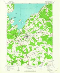
1945 Map of Broadalbin
USGS Topo · Published 1963About this map
The Sacandaga Reservoir dominates the northern landscape of this mid-century survey, its shoreline dotted with points and islands like Vandenburgh Point and Scout Island. The village of Broadalbin serves as a central hub, where numerous roads converge near the Central Sch. This era reflects a transition from early industrial footprints to a more modern infrastructure, evidenced by the presence of the Carpet City Airport and the local road network connecting outlying settlements like Perth and Vail Mills.
Find a feature on this map
42 named features on this map. Tap any name to fly to it.
Don’t see what you’re looking for? This feature index may not catch every label — zoom into the map to look around manually.
Map Details
Editions of this 1945 Broadalbin Map
This is the sole edition of this map. No revisions or reprints were ever made.
Other maps of this area

1895 · Amsterdam
USGS Topo · 1:62,500

1896 · Fonda
USGS Topo · 1:62,500

1898 · Fonda
USGS Topo · 1:62,500

1899 · Broadalbin
USGS Topo · 1:62,500

1902 · Broadalbin
USGS Topo · 1:62,500

1902 · Fonda
USGS Topo · 1:62,500

1903 · Gloversville
USGS Topo · 1:62,500

1931 · Amsterdam
USGS Topo · 1:62,500

1943 · Gloversville
USGS Topo · 1:62,500
1944 · Tribes Hill
USGS Topo · 1:24,000