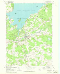
1970 Map of Broadalbin
USGS Topo · Published 1972About this map
Great Sacandaga Lake dominates the northern landscape of this 1970 revision, its jagged shoreline and islands like Scout Island defining the edge of the Adirondack State Park. The transition from the lake's recreational character to the agricultural and small-town interior of Fulton County is evident in the cluster of corners and hamlets. The village of Broadalbin serves as a central hub, where the Fonda Johnstown and Gloversville line cuts through the terrain. Evidence of the local timber and water-powered economy persists through labels like Stever Mill on Chase Creek and Union Mills further east.
Find a feature on this map
71 named features on this map. Tap any name to fly to it.
Don’t see what you’re looking for? This feature index may not catch every label — zoom into the map to look around manually.
Map Details
Editions of this 1970 Broadalbin Map
This is the sole edition of this map. No revisions or reprints were ever made.
Other maps of this area

1895 · Amsterdam
USGS Topo · 1:62,500

1896 · Fonda
USGS Topo · 1:62,500

1898 · Fonda
USGS Topo · 1:62,500

1899 · Broadalbin
USGS Topo · 1:62,500

1902 · Broadalbin
USGS Topo · 1:62,500

1902 · Fonda
USGS Topo · 1:62,500

1903 · Gloversville
USGS Topo · 1:62,500

1931 · Amsterdam
USGS Topo · 1:62,500

1943 · Gloversville
USGS Topo · 1:62,500
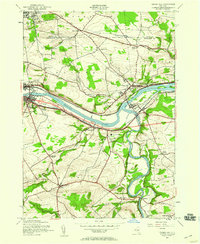
1944 · Tribes Hill
USGS Topo · 1:24,000