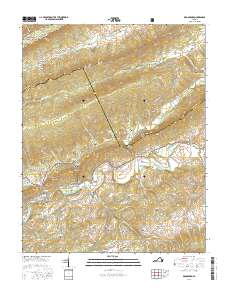
2016 Map of Broadford
USGS Topo · Published 2016About this map
The North Fork Holston River carves through this corner of Southwest Virginia, where the ridge-and-valley terrain of the Jefferson National Forest meets active valley settlements. The map highlights the high-elevation pastures and timberlands of Clinch Mountain and Flattop Mtn, while the lowlands are defined by a network of family-held cemeteries and crossroads like Broadford and Tannersville. A dense concentration of burial sites, such as Gollehon Cem, Littrell Cem, and McAllister Cem, reflects a deep ancestral footprint across Chestnut Hollow and Possum Hollow. The boundary line of the Tazewell Co Smyth Co divide runs across the northern ridges, where remote outposts like Osborns Store and Ward Cove suggest a landscape where geography and local commerce remained tightly linked into the twenty-first century.
Find a feature on this map
95 named features on this map. Tap any name to fly to it.
Don’t see what you’re looking for? This feature index may not catch every label — zoom into the map to look around manually.
Map Details
Editions of this 2016 Broadford Map
This is the sole edition of this map. No revisions or reprints were ever made.
Other maps of this area

1891 · Tazewell
USGS Topo · 1:125,000

1891 · Abingdon
USGS Topo · 1:125,000

1894 · Abingdon
USGS Topo · 1:125,000

1895 · Tazewell
USGS Topo · 1:125,000

1897 · Tazewell
USGS Topo · 1:125,000

1909 · Abingdon
USGS Topo · 1:96,000

1911 · Abingdon
USGS Topo · 1:125,000

1912 · Pounding Mill
USGS Topo · 1:62,500

1915 · Richlands
USGS Topo · 1:48,000

1916 · Pounding Mill
USGS Topo · 1:62,500