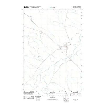
2011 Map of Broadus
USGS Topo · Published 2011About this map
The Broadus town site anchors this survey, centered near the confluence of the Powder River and Lone Tree Creek. This high-plains landscape in southeastern Montana is defined by its drainage systems, where seasonal and perennial waters like Coyote Creek, Sand Creek, and Doyle Creek carve through the terrain. Evidence of local water management and livestock infrastructure appears via the Schaffer Number 1 Dam and the Randall Ditch south of town. Notable landmarks include the Valley View Cemetery on the northern edge of the settlement and the Broadus Airport, which serves this isolated ranching community. The road network, including Powderville West Rd and Moorhead Rd, reflects the area's role as a regional hub for the surrounding river valley, while topographic features like Fivemile Hill and Preston Buttes provide distinct navigational points for the territory.
Find a feature on this map
35 named features on this map. Tap any name to fly to it.
Don’t see what you’re looking for? This feature index may not catch every label — zoom into the map to look around manually.
Map Details
Editions of this 2011 Broadus Map
This is the sole edition of this map. No revisions or reprints were ever made.
Other maps of this area

1954 · Ekalaka
USGS Topo · 1:250,000

1956 · Ekalaka
USGS Topo · 1:250,000

1958 · Ekalaka
USGS Topo · 1:250,000

1965 · Ekalaka
USGS Topo · 1:250,000

1973 · Olive
USGS Topo · 1:24,000

1973 · Lonesome Peak
USGS Topo · 1:24,000

1973 · Monday Creek
USGS Topo · 1:24,000

1973 · Moonlight Creek
USGS Topo · 1:24,000

1973 · Hawkey Creek
USGS Topo · 1:24,000
1973 · Fighting Butte
USGS Topo · 1:24,000