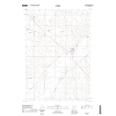
2020 Map of Broadus
USGS Topo · Published 2020About this map
Broadus serves as the focal point of this Powder River County landscape, where the Powder River carves a winding path through the dry hills and creek valleys of southeastern Montana. The town layout is clearly defined, anchored by the Powder River County Courthouse and supported by infrastructure such as the Broadus Airport and the Valley View Cem to the northeast. Beyond the settlement, the map reveals a rugged terrain marked by prominent landmarks like Preston Buttes and Fivemile Hill, alongside numerous drainage systems including Coyote Cr and Prairie Cr. Water management is evident in the presence of the Randall Ditch, which draws from the river to support local agriculture. The network of rural routes, such as Moorehead Rd and Big Powder River East Rd, underscores the importance of connectivity between isolated ranching areas and the county seat.
Find a feature on this map
42 named features on this map. Tap any name to fly to it.
Don’t see what you’re looking for? This feature index may not catch every label — zoom into the map to look around manually.
Map Details
Editions of this 2020 Broadus Map
This is the sole edition of this map. No revisions or reprints were ever made.
Other maps of this area

1954 · Ekalaka
USGS Topo · 1:250,000

1956 · Ekalaka
USGS Topo · 1:250,000

1958 · Ekalaka
USGS Topo · 1:250,000

1965 · Ekalaka
USGS Topo · 1:250,000

1973 · Olive
USGS Topo · 1:24,000

1973 · Lonesome Peak
USGS Topo · 1:24,000

1973 · Monday Creek
USGS Topo · 1:24,000

1973 · Moonlight Creek
USGS Topo · 1:24,000

1973 · Hawkey Creek
USGS Topo · 1:24,000
1973 · Fighting Butte
USGS Topo · 1:24,000