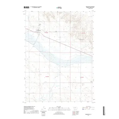
2017 Map of Broadwater
USGS Topo · Published 2017About this map
The North Platte River defines the landscape of this Morrill County region, its wide braided channel flanked by an intricate network of irrigation systems and agricultural infrastructure. The village of Broadwater sits on the north bank, serving as a focal point for the surrounding rural territory. The map reveals the critical importance of water management in this Nebraska panhandle environment, documented through numerous named waterways including the Belmont Canal, Browns Cr Canal, Beerline Canal, and the Radcliff Number 3 Canal. To the northeast, the Ancient Bluff Ruins provide a distinctive topographical landmark overlooking the river valley. Local history and genealogy are anchored by established sites such as Rose Hill Cem and Silverthorne Cem, while the Ag Air Airport reflects the continued integration of aviation into the area's agricultural operations.
Find a feature on this map
30 named features on this map. Tap any name to fly to it.
Don’t see what you’re looking for? This feature index may not catch every label — zoom into the map to look around manually.
Map Details
Editions of this 2017 Broadwater Map
This is the sole edition of this map. No revisions or reprints were ever made.
Other maps of this area

1896 · Browns Creek
USGS Topo · 1:125,000

1899 · Browns Creek
USGS Topo · 1:125,000

1899 · Sidney
USGS Topo · 1:125,000

1954 · Scottsbluff
USGS Topo · 1:250,000

1958 · Scottsbluff
USGS Topo · 1:250,000

1965 · Broadwater
USGS Topo · 1:24,000

1965 · Broadwater NW
USGS Topo · 1:24,000

1965 · Broadwater SW
USGS Topo · 1:24,000

1965 · Broadwater NE
USGS Topo · 1:24,000

1971 · Tar Valley SW
USGS Topo · 1:24,000