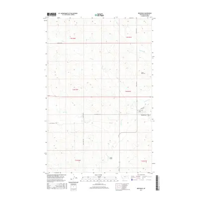
2017 Map of Brockway
USGS Topo · Published 2017About this map
The Redwater River defines the landscape of eastern McCone County, where the small community of Brockway sits at a critical junction of prairie roads and local hydrology. This 2017 survey captures the settlement's layout, specifically the street grid including Railroad Ave, 2nd Ave, and 3rd Ave near the northeastern edge of the township. Local heritage is grounded at the Brockway Cem, located just east of the main settlement area near where Ash Cr joins the river system.
Find a feature on this map
26 named features on this map. Tap any name to fly to it.
Don’t see what you’re looking for? This feature index may not catch every label — zoom into the map to look around manually.
Map Details
Editions of this 2017 Brockway Map
This is the sole edition of this map. No revisions or reprints were ever made.
Other maps of this area

1954 · Glendive
USGS Topo · 1:250,000

1957 · Glendive
USGS Topo · 1:250,000

1958 · Glendive
USGS Topo · 1:250,000

1965 · Watkins
USGS Topo · 1:24,000
1965 · Berry School
USGS Topo · 1:24,000

1982 · Circle
USGS Topo · 1:100,000

1983 · Youngquist Mine
USGS Topo · 1:24,000

1983 · Brockway NE
USGS Topo · 1:24,000
1983 · Brockway
USGS Topo · 1:24,000
1983 · Big Sheep Mountain NW
USGS Topo · 1:24,000