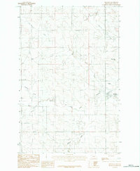
1983 Map of Brockway
USGS Topo · Published 1983About this map
Brockway serves as the primary settlement hub in this 1983 McCone County landscape, situated where the Redwater River meets a network of vital prairie drainages. The local geography is defined by a series of named watercourses, including Cotter Creek, Beauty Creek, and the curiously named Dirty Creek, which carve through the high plains terrain. A notable cultural landmark is the Race Track located just northwest of the town center, suggesting a local community focal point in the late 20th century.
Find a feature on this map
12 named features on this map. Tap any name to fly to it.
Don’t see what you’re looking for? This feature index may not catch every label — zoom into the map to look around manually.
Map Details
Editions of this 1983 Brockway Map
This is the sole edition of this map. No revisions or reprints were ever made.
Other maps of this area

1954 · Glendive
USGS Topo · 1:250,000

1957 · Glendive
USGS Topo · 1:250,000

1958 · Glendive
USGS Topo · 1:250,000

1965 · Watkins
USGS Topo · 1:24,000
1965 · Berry School
USGS Topo · 1:24,000

1982 · Circle
USGS Topo · 1:100,000

1983 · Youngquist Mine
USGS Topo · 1:24,000

1983 · Brockway NE
USGS Topo · 1:24,000
1983 · Big Sheep Mountain NW
USGS Topo · 1:24,000
1983 · Johnson Coulee East
USGS Topo · 1:24,000