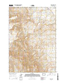
2014 Map of Brogan
USGS Topo · Published 2014About this map
Brogan sits at the northern edge of this high-desert landscape in Malheur County, where the Willow Creek Valley opens into a complex system of agricultural water management. The town is marked by its grid of local roads, including 5th Ave and 8th Ave, and is served by the historic John Day Hwy. An extensive network of irrigation infrastructure is visible, including the Low Line Ditch and High Line Ditch, which redirect water from the Willow Cr drainage to support the arid flats. To the southwest, the terrain rises toward the summit of Cottonwood Mountain and the high table of Thorn Flat. This 2014 survey documents a rugged ranching and farming landscape defined by numerous small-scale water projects, from the Pole Cr Reservoir to the Lockett Reservoir, and remote landmarks like Shell Rock Spring and Upper Turner Spring.
Find a feature on this map
45 named features on this map. Tap any name to fly to it.
Don’t see what you’re looking for? This feature index may not catch every label — zoom into the map to look around manually.
Map Details
Editions of this 2014 Brogan Map
This is the sole edition of this map. No revisions or reprints were ever made.
Other maps of this area

1950 · Jamieson
USGS Topo · 1:62,500

1951 · Huntington
USGS Topo · 1:62,500

1955 · Baker
USGS Topo · 1:250,000

1959 · Baker
USGS Topo · 1:250,000

1964 · Bridgeport
USGS Topo · 1:62,500

1964 · Brogan
USGS Topo · 1:62,500

1980 · Brogan
USGS Topo · 1:100,000
1988 · Birch Creek Meadow
USGS Topo · 1:24,000
1988 · Jamieson
USGS Topo · 1:24,000
1988 · Hope Butte
USGS Topo · 1:24,000