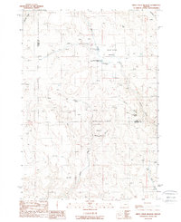
1988 Map of Birch Creek Meadow
USGS Topo · Published 1988About this map
Birch Creek Meadow lies at the heart of this high-desert landscape along the boundary of Malheur and Baker Counties. Surveyed in the mid-1980s, the terrain is defined by a complex drainage system including the West Fork Birch Creek and a network of named gulches such as Matthew Gulch and Dry Gulch. Water management is central to this area's utility, evidenced by the sequential Kivett Reservoir No 1, Kivett Reservoir No 2, and Kivett Reservoir No 3. These man-made features, alongside numerous isolated springs like Falkner Spring and Cottonwood Spring, supported the region's ranching and resource needs. Small-scale industrial activity is marked by a Gravel Pit and scattered Prospects, indicating early attempts to extract value from the rocky soil near the Bluff.
Find a feature on this map
23 named features on this map. Tap any name to fly to it.
Don’t see what you’re looking for? This feature index may not catch every label — zoom into the map to look around manually.
Map Details
Editions of this 1988 Birch Creek Meadow Map
This is the sole edition of this map. No revisions or reprints were ever made.
Other maps of this area

1950 · Jamieson
USGS Topo · 1:62,500

1951 · Huntington
USGS Topo · 1:62,500

1955 · Baker
USGS Topo · 1:250,000

1959 · Baker
USGS Topo · 1:250,000

1964 · Bridgeport
USGS Topo · 1:62,500

1964 · Brogan
USGS Topo · 1:62,500

1980 · Brogan
USGS Topo · 1:100,000
1988 · Mc Carthy Ridge
USGS Topo · 1:24,000
1988 · Rye Valley
USGS Topo · 1:24,000
1988 · Jamieson
USGS Topo · 1:24,000