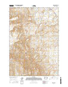
2017 Map of Brogan
USGS Topo · Published 2017About this map
Brogan serves as the primary focal point in this high-desert landscape of Malheur County, where the settlement's layout is defined by streets like 5th Ave and 7th Ave. To the west, the terrain rises sharply toward the summit of Cottonwood Mountain and the expansive Thorn Flat, while the lower elevations are marked by an intricate network of irrigation features. The managed water system is evident through the Low Line Ditch and High Line Ditch, which redirect flows from sources like Black Cr and Pole Cr to support local agriculture. This reliance on water management is further highlighted by a series of upland catchments including Wood Reservoir and Pritchard Reservoir. For those researching local lineages, the Brogan Cem sits north of the main town site along Cemetery Rd, providing a specific point of interest for genealogical study.
Find a feature on this map
44 named features on this map. Tap any name to fly to it.
Don’t see what you’re looking for? This feature index may not catch every label — zoom into the map to look around manually.
Map Details
Editions of this 2017 Brogan Map
This is the sole edition of this map. No revisions or reprints were ever made.
Other maps of this area

1950 · Jamieson
USGS Topo · 1:62,500

1951 · Huntington
USGS Topo · 1:62,500

1955 · Baker
USGS Topo · 1:250,000

1959 · Baker
USGS Topo · 1:250,000

1964 · Bridgeport
USGS Topo · 1:62,500

1964 · Brogan
USGS Topo · 1:62,500

1980 · Brogan
USGS Topo · 1:100,000
1988 · Birch Creek Meadow
USGS Topo · 1:24,000
1988 · Jamieson
USGS Topo · 1:24,000
1988 · Hope Butte
USGS Topo · 1:24,000