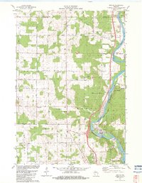
1982 Map of Brokaw
USGS Topo · Published 1983About this map
The Wisconsin River carves a deep path through the central Wisconsin landscape of the early 1980s, serving as a corridor for industry and transport. The settlement of Brokaw is anchored by a large riverfront industrial site with extensive rail service provided by the Chicago and North Western and C M ST P & P lines. This industrial footprint contrasts with the surrounding agricultural and rural character of the townships of Maine, Berlin, and Texas.
Find a feature on this map
43 named features on this map. Tap any name to fly to it.
Don’t see what you’re looking for? This feature index may not catch every label — zoom into the map to look around manually.
Map Details
Editions of this 1982 Brokaw Map
This is the sole edition of this map. No revisions or reprints were ever made.
Other maps of this area

1899 · Wausau
USGS Topo · 1:125,000

1902 · Wausau
USGS Topo · 1:125,000

1902 · Marathon
USGS Topo · 1:125,000

1951 · Merrill
USGS Topo · 1:48,000

1951 · Hamburg
USGS Topo · 1:48,000

1953 · Wausau
USGS Topo · 1:48,000

1953 · Marathon
USGS Topo · 1:48,000

1954 · Iron Mountain
USGS Topo · 1:250,000

1955 · Green Bay
USGS Topo · 1:250,000

1959 · Iron Mountain
USGS Topo · 1:250,000