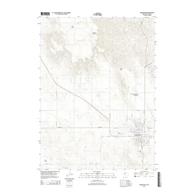
2014 Map of Broken Bow
USGS Topo · Published 2014About this map
Broken Bow sits at the intersection of prairie tablelands and dissected canyon topography in central Nebraska. The settlement’s residential grid is clearly defined, extending south toward the Broken Bow Cem and north toward the local aviation hub at Broken Bow Municipal Airport/Keith Glaze Field. The surrounding Custer County landscape is characterized by the complex drainage patterns of Mud Cr and its tributaries, including N Br Mud Cr and S Br Mud Cr, which carve through the high ground of East Table and Tappan Valley. Genealogists will find the specific locations of Saint Joseph Cem and other local landmarks useful for family history research. The rural road network, including Ryno Rd and Callaway Rd, follows the irregular terrain of Union Valley and Deadmans Canyon, illustrating how the region's natural geography has shaped modern transportation and agricultural boundaries.
Find a feature on this map
46 named features on this map. Tap any name to fly to it.
Don’t see what you’re looking for? This feature index may not catch every label — zoom into the map to look around manually.
Map Details
Editions of this 2014 Broken Bow Map
This is the sole edition of this map. No revisions or reprints were ever made.
Other maps of this area

1951 · Broken Bow NE
USGS Topo · 1:24,000

1951 · Broken Bow SW
USGS Topo · 1:24,000

1951 · Lillian
USGS Topo · 1:24,000

1951 · Anselmo
USGS Topo · 1:24,000

1951 · Broken Bow
USGS Topo · 1:24,000

1951 · Broken Bow SE
USGS Topo · 1:24,000

1951 · Merna
USGS Topo · 1:24,000

1951 · Callaway SE
USGS Topo · 1:24,000

1951 · Round Valley
USGS Topo · 1:24,000

1955 · Broken Bow
USGS Topo · 1:250,000