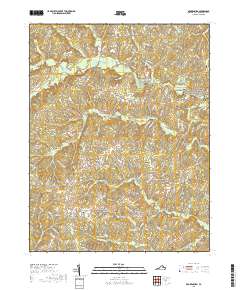
2019 Map of Brokenburg
USGS Topo · Published 2019About this map
The Po River and Ta River systems define this portion of Spotsylvania County, where the landscape is marked by colonial-era crossroads and American Civil War history. Large portions of the northeastern quadrant are preserved within the Fredericksburg and Spotsylvania County Battlefields Memorial National Military Park, reflecting the region's strategic importance during the 1864 Overland Campaign. Small, long-established communities like Todds Tavern, Brokenburg, and Post Oak serve as focal points for the surrounding rural homesteads. Genealogists will find significant value in the distribution of family and congregational burial grounds, including the Hebron Baptist Church Cem, Mine Road Cem, and Little Mine Road Cem. The network of secondary roads, such as Courthouse Rd and Hebron Church Rd, connects these historic settlements across a terrain of winding creeks and small ponds like Jennings Pond and Towles Pond.
Find a feature on this map
119 named features on this map. Tap any name to fly to it.
Don’t see what you’re looking for? This feature index may not catch every label — zoom into the map to look around manually.
Map Details
Editions of this 2019 Brokenburg Map
This is the sole edition of this map. No revisions or reprints were ever made.
Other maps of this area

1887 · Spottsylvania
USGS Topo · 1:125,000

1892 · Spottsylvania
USGS Topo · 1:125,000

1942 · Ladysmith
USGS Topo · 1:31,680

1942 · Partlow
USGS Topo · 1:31,680

1942 · Belmont
USGS Topo · 1:31,680

1942 · Contrary Creek
USGS Topo · 1:31,680

1942 · Spotsylania
USGS Topo · 1:31,680

1942 · Brokenburg
USGS Topo · 1:31,680

1943 · Chancellorsville
USGS Topo · 1:24,000

1943 · Salem Church
USGS Topo · 1:24,000