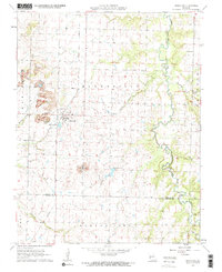
1962 Map of Bronaugh
USGS Topo · Published 1964About this map
Bronaugh sits at the heart of this early 1960s landscape, serving as a hub for the Missouri Pacific railroad line that cuts through the southwestern Missouri plains. The map illustrates a region defined by its watercourses and small rural congregations, featuring landmarks such as Worsley Ch to the west and Fairview Ch overlooking the meandering Little Dry Wood Creek in the northeast. The presence of a Strip Mine in the northwest corner near Harrison indicates the localized coal extraction efforts of the era, while the southern border tracks the transition from Vernon Co into Barton Co. Beyond the town center, the terrain is shaped by numerous smaller streams like Prairie Flower Branch and Pleasant Run Creek, supporting a dispersed agricultural settlement pattern tied to the Barton City and Leroy townships.
Find a feature on this map
19 named features on this map. Tap any name to fly to it.
Don’t see what you’re looking for? This feature index may not catch every label — zoom into the map to look around manually.
Map Details
Editions of this 1962 Bronaugh Map
2 editions found
Other maps of this area

1884 · Fort Scott
USGS Topo · 1:125,000

1886 · Nevada
USGS Topo · 1:125,000

1886 · Fort Scott
USGS Topo · 1:125,000

1893 · Fort Scott
USGS Topo · 1:125,000

1894 · Nevada
USGS Topo · 1:125,000

1933 · Camp Clark
USGS Topo · 1:24,000

1939 · Deerfield
USGS Topo · 1:24,000

1939 · Moundville
USGS Topo · 1:24,000

1942 · Deerfield
USGS Topo · 1:24,000
1942 · Moundville
USGS Topo · 1:24,000