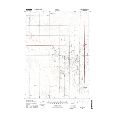
2015 Map of Brookings
USGS Topo · Published 2015About this map
South Dakota State University serves as a central landmark for this eastern South Dakota landscape, where the urban grid of Brookings meets the expansive plains. The city's growth is evident in the residential developments branching toward the Brookings Regional Airport and along the periphery of the campus. A trio of burial grounds, including Greenwood Cem, Lutheran Cem, and Calvary Cem, are clustered south of the city center near the winding course of the Sixmile Cr.
Find a feature on this map
69 named features on this map. Tap any name to fly to it.
Don’t see what you’re looking for? This feature index may not catch every label — zoom into the map to look around manually.
Map Details
Editions of this 2015 Brookings Map
This is the sole edition of this map. No revisions or reprints were ever made.
Other maps of this area

1953 · Watertown
USGS Topo · 1:250,000

1958 · Watertown
USGS Topo · 1:250,000

1964 · Brookings
USGS Topo · 1:24,000

1964 · Medary
USGS Topo · 1:24,000

1964 · Flandreau NW
USGS Topo · 1:24,000

1964 · Aurora
USGS Topo · 1:24,000

1968 · Brookings NE
USGS Topo · 1:24,000

1968 · Bruce
USGS Topo · 1:24,000

1968 · Volga
USGS Topo · 1:24,000
1968 · Rutland NW
USGS Topo · 1:24,000