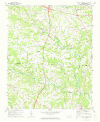
1970 Map of Brooks Crossroads
USGS Topo · Published 1973About this map
The rolling agricultural landscape of the Yadkin Co and Iredell Co border is defined by a dense network of country roads connecting established rural settlements. At the northern edge, Brooks Crossroads and Hamptonville serve as local hubs, while smaller communities like Eagle Mills and Union Grove anchor the central and southern sections. The map records a time of significant infrastructure change, as a major highway is shown as under construction bisecting the quadrangle from north to south.
Find a feature on this map
34 named features on this map. Tap any name to fly to it.
Don’t see what you’re looking for? This feature index may not catch every label — zoom into the map to look around manually.
Map Details
Editions of this 1970 Brooks Crossroads Map
This is the sole edition of this map. No revisions or reprints were ever made.
Other maps of this area

1891 · Yadkinville
USGS Topo · 1:125,000

1893 · Statesville
USGS Topo · 1:125,000

1893 · Yadkinville
USGS Topo · 1:125,000

1953 · Charlotte
USGS Topo · 1:250,000

1953 · Winston-Salem
USGS Topo · 1:250,000

1954 · Charlotte
USGS Topo · 1:250,000

1955 · Winston-Salem
USGS Topo · 1:250,000

1960 · Charlotte
USGS Topo · 1:250,000

1962 · Winston-Salem
USGS Topo · 1:250,000

1962 · Charlotte
USGS Topo · 1:250,000