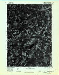
1975 Map of Brooks SE
USGS Topo · Published 1980About this map
Monroe and Waldo anchor this orthophotoquad, which uses 1975 aerial photography to reveal the mid-century agricultural and woodland patterns of Waldo County. The landscape is defined by the winding course of Marsh Stream, which cuts through the northern portion of the quadrangle. Small rural intersections like Town House Corners and Nickerson Mills provide a clear view of how these settlements were positioned along historic transport routes. Unlike a traditional topographic map, this imagery-based survey shows the exact density of forest cover and the precise boundaries of active fields and clearings at the time. Researchers can trace the layout of Brooks and the surrounding homesteads as they appeared shortly before the 1980s, documenting a era when rural Maine's land use was largely dictated by the local drainage of the Stream.
Find a feature on this map
7 named features on this map. Tap any name to fly to it.
Don’t see what you’re looking for? This feature index may not catch every label — zoom into the map to look around manually.
Map Details
Editions of this 1975 Brooks SE Map
This is the sole edition of this map. No revisions or reprints were ever made.
Other maps of this area

1900 · Bucksport
USGS Topo · 1:62,500

1902 · Bucksport
USGS Topo · 1:62,500

1902 · Castine
USGS Topo · 1:62,500

1904 · Castine
USGS Topo · 1:62,500

1905 · Penobscot Bay
USGS Topo · 1:125,000

1915 · Belfast
USGS Topo · 1:62,500

1917 · Belfast
USGS Topo · 1:62,500

1932 · Brooks
USGS Topo · 1:62,500

1941 · Belfast
USGS Topo · 1:62,500

1941 · Castine
USGS Topo · 1:62,500