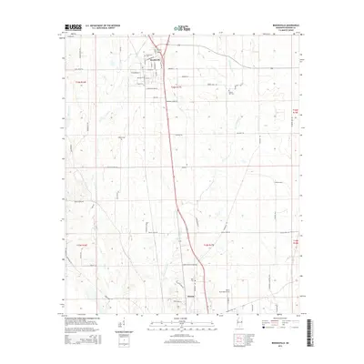
2015 Map of Brooksville
USGS Topo · Published 2015About this map
Brooksville serves as a primary hub of settlement in Noxubee County, situated at the intersection of several key routes including MS Hwy 145. The landscape is defined by its agricultural and drainage patterns, with the town’s grid expanding outward toward various rural cemeteries and landmarks. To the south, the city of Macon anchors the sheet, accompanied by the Macon Municipal Airport. Numerous watercourses like Horse Hunters Cr and Joes Cr traverse the township boundaries of t16n r17e and t15n r17e. The distribution of burial sites, such as Pilgrim Rest Cem and Halls Cem, suggests a long history of established family and community ties throughout this portion of the Mississippi Black Belt. These features, along with the Brooksville Cem, provide essential data points for understanding the early 21st-century development and heritage of the region.
Find a feature on this map
66 named features on this map. Tap any name to fly to it.
Don’t see what you’re looking for? This feature index may not catch every label — zoom into the map to look around manually.
Map Details
Editions of this 2015 Brooksville Map
This is the sole edition of this map. No revisions or reprints were ever made.
Other maps of this area

1953 · West Point
USGS Topo · 1:250,000

1958 · West Point
USGS Topo · 1:250,000

1959 · Artesia
USGS Topo · 1:62,500

1960 · Columbus
USGS Topo · 1:62,500

1963 · West Point
USGS Topo · 1:250,000

1973 · Cliftonville
USGS Topo · 1:24,000

1973 · McLeod
USGS Topo · 1:24,000
1973 · Brooksville
USGS Topo · 1:24,000
1973 · Mashulaville
USGS Topo · 1:24,000
1973 · Lynn Creek
USGS Topo · 1:24,000