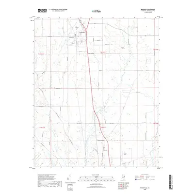
2018 Map of Brooksville
USGS Topo · Published 2018About this map
Brooksville and the northern outskirts of Macon anchor this portrait of Noxubee County, where a network of rural roads connects established family and community landmarks. The landscape is defined by the winding paths of Horse Hunters Cr and Joes Cr, which traverse the agricultural terrain between the two primary settlements. For those researching local heritage, the map identifies several distinct burial grounds, including Brooksville Cem and the Pilgrim Rest Cem further east. A complex grid of thoroughfares like Old Macon RD and Buggs Ferry RD illustrates the connectivity of the region, while the Macon Municipal Airport serves as a modern waypoint near the southern border. The transition from the residential blocks of Brooksville to the surrounding farmland reveals a community structure rooted in these named creeks and historic cemetery sites.
Find a feature on this map
61 named features on this map. Tap any name to fly to it.
Don’t see what you’re looking for? This feature index may not catch every label — zoom into the map to look around manually.
Map Details
Editions of this 2018 Brooksville Map
This is the sole edition of this map. No revisions or reprints were ever made.
Other maps of this area

1953 · West Point
USGS Topo · 1:250,000

1958 · West Point
USGS Topo · 1:250,000

1959 · Artesia
USGS Topo · 1:62,500

1960 · Columbus
USGS Topo · 1:62,500

1963 · West Point
USGS Topo · 1:250,000

1973 · Cliftonville
USGS Topo · 1:24,000

1973 · McLeod
USGS Topo · 1:24,000
1973 · Brooksville
USGS Topo · 1:24,000
1973 · Mashulaville
USGS Topo · 1:24,000
1973 · Lynn Creek
USGS Topo · 1:24,000