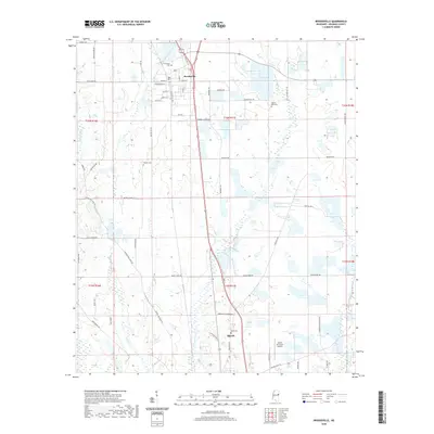
2020 Map of Brooksville
USGS Topo · Published 2020About this map
The town of Brooksville anchors this Noxubee County landscape, serving as a hub for a network of rural roads and land tracts defined by the Public Land Survey System. The area is characterized by several watercourses, including Horse Hunters Cr and Wet Water Cr, which carve through the terrain between small family and community landmarks. Genealogists will find significant value in the distribution of local burial sites such as Brooksville Cem and Pilgrim Rest Cem, alongside smaller plots like Tolliver Cem. Toward the southern edge of the sheet, the northern reaches of Macon appear, including the Macon Municipal Airport. The map documents a predominantly agricultural and residential region where long-established routes like Old Macon Rd and Macon-Lynn Creek Rd connect dispersed homesteads and farms.
Find a feature on this map
60 named features on this map. Tap any name to fly to it.
Don’t see what you’re looking for? This feature index may not catch every label — zoom into the map to look around manually.
Map Details
Editions of this 2020 Brooksville Map
This is the sole edition of this map. No revisions or reprints were ever made.
Other maps of this area

1953 · West Point
USGS Topo · 1:250,000

1958 · West Point
USGS Topo · 1:250,000

1959 · Artesia
USGS Topo · 1:62,500

1960 · Columbus
USGS Topo · 1:62,500

1963 · West Point
USGS Topo · 1:250,000

1973 · Cliftonville
USGS Topo · 1:24,000

1973 · McLeod
USGS Topo · 1:24,000
1973 · Brooksville
USGS Topo · 1:24,000
1973 · Mashulaville
USGS Topo · 1:24,000
1973 · Lynn Creek
USGS Topo · 1:24,000