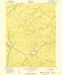
1951 Map of Brookville
USGS Topo · Published 1951About this map
Cranberry Bogs and the labyrinthine waterways of the Pine Barrens dominate this 1951 landscape, centered on the intersection of Lacey, Ocean, and Union townships. Small settlements like Brookville and Howardsville appear as modest clearings in a dense network of branches and creeks, including the North Branch Forked River and Oyster Creek. The terrain is characterized by subtle elevation changes, most notably at Forked River Mtn, and a tradition of local industry evidenced by Wells Mill. Transportation through this marshy interior is facilitated by Bayshore Drive and Whiting Road. The map documents a specific moment in New Jersey's coastal hinterland before significant modern development, where the land was defined by timber, bog iron, and agriculture.
Find a feature on this map
33 named features on this map. Tap any name to fly to it.
Don’t see what you’re looking for? This feature index may not catch every label — zoom into the map to look around manually.
Map Details
Editions of this 1951 Brookville Map
This is the sole edition of this map. No revisions or reprints were ever made.
Other maps of this area

1884 · Whitings
USGS Topo · 1:62,500

1888 · Barnegat
USGS Topo · 1:62,500

1888 · Little Egg Harbor
USGS Topo · 1:62,500

1888 · Long Beach
USGS Topo · 1:62,500

1888 · Whitings
USGS Topo · 1:62,500

1893 · Little Egg Harbor
USGS Topo · 1:62,500

1893 · Long Beach
USGS Topo · 1:62,500

1893 · Barnegat
USGS Topo · 1:62,500

1898 · Barnegat
USGS Topo · 1:62,500

1919 · Long Beach
USGS Topo · 1:62,500