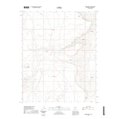
2020 Map of Broom Mountain
USGS Topo · Published 2020About this map
Broom Mtn anchors the high desert landscape of this portion of Cibola County, where intricate canyon systems and flat-topped mesas define the drainage patterns. The geography is dominated by Blue Water Canyon and the seasonal flows of Blue Water Cr and Gallegos Cr, which feed into various stock tanks and reservoirs essential for land management in this arid region. High points like Blue Water Mesa and Victorino Mesa provide prominent landmarks overlooking a network of remote infrastructure, including Indian Svc Rte 212. Numerous named water catchments such as Henderson Reservoir, Bates Tank, and Red Windmill Tank illustrate the historical and ongoing necessity of water storage for ranching or local use. The presence of Apache Spring and Seven Cedar Trees Mesa further indicates a landscape shaped by specific natural landmarks and vital water sources.
Find a feature on this map
31 named features on this map. Tap any name to fly to it.
Don’t see what you’re looking for? This feature index may not catch every label — zoom into the map to look around manually.
Map Details
Editions of this 2020 Broom Mountain Map
This is the sole edition of this map. No revisions or reprints were ever made.
Other maps of this area

1917 · Cerro Verde
USGS Topo · 1:125,000

1917 · Broom Mountain
USGS Topo · 1:125,000

1954 · Socorro
USGS Topo · 1:250,000

1958 · Socorro
USGS Topo · 1:250,000

1961 · Marmon Ranch
USGS Topo · 1:24,000
1961 · East Mesa
USGS Topo · 1:24,000
1961 · Blue Mesa
USGS Topo · 1:24,000

1962 · Socorro
USGS Topo · 1:250,000

1964 · Wiley Mesa
USGS Topo · 1:24,000

1964 · Field Ranch
USGS Topo · 1:24,000