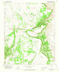
1964 Map of Broom Mountain
USGS Topo · Published 1968About this map
Laguna Indian Reservation (Acoma Purchase) dominates the northern landscape of this 1964 field-checked survey, showcasing the high-desert topography of the Acoma region. The map reveals a sophisticated network of water management essential for ranching and settlement in an arid environment, featuring numerous named catchments like Henderson Reservoir, North Sanchez Tank, and Alcon Tank. The terrain is defined by dramatic elevations including Broom Mountain and the broad expanses of Victorino Mesa and Mesa Del Oro. Subtle human imprints are visible through family-named landmarks and infrastructure, such as the Henderson Windmill and Ward Windmill, alongside seasonal watercourses like Blue Water Creek and Gallegos Creek. This survey provides a precise record of the fence lines and water sources that sustained the local economy before more modern developments altered the traditional use of the land.
Find a feature on this map
30 named features on this map. Tap any name to fly to it.
Don’t see what you’re looking for? This feature index may not catch every label — zoom into the map to look around manually.
Map Details
Editions of this 1964 Broom Mountain Map
This is the sole edition of this map. No revisions or reprints were ever made.
Other maps of this area

1917 · Cerro Verde
USGS Topo · 1:125,000

1917 · Broom Mountain
USGS Topo · 1:125,000

1954 · Socorro
USGS Topo · 1:250,000

1958 · Socorro
USGS Topo · 1:250,000

1961 · Marmon Ranch
USGS Topo · 1:24,000
1961 · East Mesa
USGS Topo · 1:24,000
1961 · Blue Mesa
USGS Topo · 1:24,000

1962 · Socorro
USGS Topo · 1:250,000

1964 · Wiley Mesa
USGS Topo · 1:24,000

1964 · Field Ranch
USGS Topo · 1:24,000