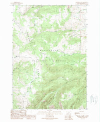
1988 Map of Broomtail Ridge
USGS Topo · Published 1989About this map
Beaverhead National Forest covers this high-altitude landscape in the late 1980s, dominated by the massive Gravelly Range and the prominent spine of Broomtail Ridge. The terrain is defined by a complex drainage system, where high-country features like Cherry Lakes and Clover Meadows transition into deep incisions like Beartrap Canyon. A network of gulches, including Morgan Gulch, Sunrise Gulch, and Johnny Gulch, demonstrates the intricate erosional patterns of the Madison County highlands. The map illustrates a wilderness largely shaped by water, with the Ruby Creek system and its South Fork carving through the southern reaches, while the Middle Fork Warm Spring Creek and Grindstone Creek suggest the variety of riparian environments found within these protected federal lands.
Find a feature on this map
18 named features on this map. Tap any name to fly to it.
Don’t see what you’re looking for? This feature index may not catch every label — zoom into the map to look around manually.
Map Details
Editions of this 1988 Broomtail Ridge Map
This is the sole edition of this map. No revisions or reprints were ever made.
Other maps of this area

1888 · Three Forks
USGS Topo · 1:250,000

1894 · Three Forks
USGS Topo · 1:250,000

1895 · Three Forks
USGS Topo · 1:250,000

1947 · Bozeman
USGS Topo · 1:250,000

1948 · Bozeman
USGS Topo · 1:250,000

1949 · Varney
USGS Topo · 1:62,500

1950 · Cliff Lake
USGS Topo · 1:62,500

1950 · Cameron
USGS Topo · 1:62,500

1950 · Monument Ridge
USGS Topo · 1:62,500

1955 · Bozeman
USGS Topo · 1:250,000