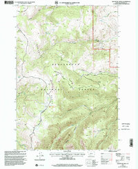
1997 Map of Broomtail Ridge
USGS Topo · Published 2002About this map
Beaverhead National Forest land dominates this high-altitude landscape in Madison County, where the massive spine of the Gravelly Range dictates the flow of water and travel. The topography is defined by significant elevation changes, with the Broomtail Ridge providing a natural divider between north-flowing drainages like Morgan Gulch and the southern waters of Warm Springs Creek.
Find a feature on this map
32 named features on this map. Tap any name to fly to it.
Don’t see what you’re looking for? This feature index may not catch every label — zoom into the map to look around manually.
Map Details
Editions of this 1997 Broomtail Ridge Map
This is the sole edition of this map. No revisions or reprints were ever made.
Other maps of this area

1888 · Three Forks
USGS Topo · 1:250,000

1894 · Three Forks
USGS Topo · 1:250,000

1895 · Three Forks
USGS Topo · 1:250,000

1947 · Bozeman
USGS Topo · 1:250,000

1948 · Bozeman
USGS Topo · 1:250,000

1949 · Varney
USGS Topo · 1:62,500

1950 · Cliff Lake
USGS Topo · 1:62,500

1950 · Cameron
USGS Topo · 1:62,500

1950 · Monument Ridge
USGS Topo · 1:62,500

1955 · Bozeman
USGS Topo · 1:250,000