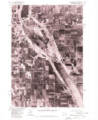
1977 Map of Browns Valley
USGS Topo · Published 1979About this map
Browns Valley sits at a critical geographic juncture on the Continental Divide, where this 1977 orthophotoquad reveals the intricate water patterns of the Traverse Gap. The imagery provides a clear view of the narrow valley floor between Lake Traverse, which flows north toward the Arctic, and Big Stone Lake, the headwaters of the Minnesota River flowing south to the Gulf of Mexico. This landscape, shaped by the ancient glacial River Warren, is shown in high detail by the Geological Survey in cooperation with the Bureau of Indian Affairs. The aerial perspective highlights the agricultural grid surrounding the settlement and the winding course of the Little Minnesota River as it enters the head of the lake, offering a precise look at the land use and drainage patterns of this border region during the late 1970s.
Find a feature on this map
4 named features on this map. Tap any name to fly to it.
Don’t see what you’re looking for? This feature index may not catch every label — zoom into the map to look around manually.
Map Details
Editions of this 1977 Browns Valley Map
This is the sole edition of this map. No revisions or reprints were ever made.
Other maps of this area

1916 · Peever
USGS Topo · 1:62,500

1916 · Beardsley
USGS Topo · 1:62,500

1918 · Peever
USGS Topo · 1:62,500

1918 · Beardsley
USGS Topo · 1:62,500

1953 · Milbank
USGS Topo · 1:250,000

1954 · Big Stone Lake
USGS Topo · 1:62,500

1958 · Milbank
USGS Topo · 1:250,000

1970 · Wilmot NW
USGS Topo · 1:24,000

1971 · Browns Valley
USGS Topo · 1:24,000
1971 · Peever
USGS Topo · 1:24,000
Featured Places
- Browns Valley, MN
- Lake Traverse District, SD
- Big Stone County, MN
- Traverse County, MN
- Roberts County, SD