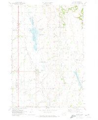
1971 Map of Peever
USGS Topo · Published 1974About this map
Peever stands as the primary settlement in this 1971 Roberts County survey, situated along the Chicago Milwaukee St Paul and Pacific railroad line. The landscape is defined by the high concentration of managed wetlands and prairies characteristic of the prairie pothole region, including the large Peeper Slough State Wildlife Management Area and various National Waterfowl Production Areas. These water bodies and marshlands are part of a complex hydrologic network feeding into the Little Minnesota River and Jorgenson River.
Find a feature on this map
25 named features on this map. Tap any name to fly to it.
Don’t see what you’re looking for? This feature index may not catch every label — zoom into the map to look around manually.
Map Details
Editions of this 1971 Peever Map
This is the sole edition of this map. No revisions or reprints were ever made.
Other maps of this area

1916 · Peever
USGS Topo · 1:62,500

1918 · Peever
USGS Topo · 1:62,500

1953 · Milbank
USGS Topo · 1:250,000

1958 · Milbank
USGS Topo · 1:250,000

1970 · Sisseton
USGS Topo · 1:24,000

1970 · Summit NE
USGS Topo · 1:24,000

1970 · Wilmot NW
USGS Topo · 1:24,000

1970 · Goodwill
USGS Topo · 1:24,000

1971 · Browns Valley
USGS Topo · 1:24,000
1971 · Peever NW
USGS Topo · 1:24,000
Featured Places
- Peever, Old Agency District
- Old Agency District, SD
- Lake Traverse District, SD
- Big Course District, SD
- Roberts County, SD