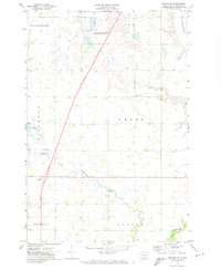
1971 Map of Peever NW
USGS Topo · Published 1974About this map
National Waterfowl Production Area land dominates the northern portion of this Roberts County landscape, highlighting a region defined by its wetland ecology and glacial prairie potholes. The Little Minnesota River winds across the southern sections, while Cottonwood Slough and Jim Creek provide drainage through the center of the townships. Rural social and civic structures are scattered throughout the quadrangle, including the Concordia Pioneer Ch, a local Cem, and a Townhall located near the eastern boundary.
Find a feature on this map
18 named features on this map. Tap any name to fly to it.
Don’t see what you’re looking for? This feature index may not catch every label — zoom into the map to look around manually.
Map Details
Editions of this 1971 Peever NW Map
This is the sole edition of this map. No revisions or reprints were ever made.
Other maps of this area

1916 · Peever
USGS Topo · 1:62,500

1917 · New Effington
USGS Topo · 1:62,500

1918 · Peever
USGS Topo · 1:62,500

1953 · Milbank
USGS Topo · 1:250,000

1958 · Milbank
USGS Topo · 1:250,000

1964 · Claire City
USGS Topo · 1:24,000

1970 · Sisseton
USGS Topo · 1:24,000

1970 · Goodwill
USGS Topo · 1:24,000

1971 · Browns Valley
USGS Topo · 1:24,000
1971 · Peever
USGS Topo · 1:24,000
Featured Places
- Old Agency District, SD
- Lake Traverse District, SD
- Heipa District
- Long Hollow District, SD
- Roberts County, SD