
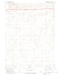
1972 Map of Brownson
USGS Topo · Published 1975About this map
An Abandoned Ammunition Depot dominates the northern landscape of this Cheyenne County region during the early 1970s, reflecting a period of transition for military infrastructure in the High Plains. The settlement of Brownson sits along the Union Pacific line, where the rail corridor parallels Lodgepole Creek and Interstate 80. This corridor serves as a busy transit hub, evidenced by the presence of a Landing Strip, a Rest Area, and an Old Railroad Grade that speaks to earlier transit alignments.
Find a feature on this map
23 named features on this map. Tap any name to fly to it.
Don’t see what you’re looking for? This feature index may not catch every label — zoom into the map to look around manually.
Map Details
Editions of this 1972 Brownson Map
This is the sole edition of this map. No revisions or reprints were ever made.
Other maps of this area

1899 · Sidney
USGS Topo · 1:125,000

1954 · Scottsbluff
USGS Topo · 1:250,000

1958 · Scottsbluff
USGS Topo · 1:250,000

1972 · Gurley
USGS Topo · 1:24,000

1972 · Mud Springs SW
USGS Topo · 1:24,000

1972 · Easterly Airport
USGS Topo · 1:24,000

1972 · Lorenzo
USGS Topo · 1:24,000

1972 · Point Of Rocks
USGS Topo · 1:24,000

1972 · Mud Springs SE
USGS Topo · 1:24,000
1972 · Sidney Muni. Airport
USGS Topo · 1:24,000