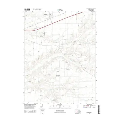
2015 Map of Brownstown
USGS Topo · Published 2015About this map
The village of Brownstown anchors the northern edge of this Fayette County survey, where the prairie begins to break into the complex drainage of the Hickory Cr watershed. The landscape is a mix of geometric agricultural road grids and the meandering courses of Sandy Run, Overcup Cr, and Little Hickory Cr. A high density of rural burial grounds provides significant genealogical value, including the centrally located Arm Prairie Cem, the German Reformed Cem near the eastern border, and the Winslow-Pilcher Cem further west. Smaller crossroads communities such as Confidence and Wilberton mark the southern half of the map, with Wilberton situated near the Frogtown Cem. These scattered settlements and named landmarks like Oliver Reece Pond reflect the persistent character of south-central Illinois as it appeared in the mid-2010s, maintaining its traditional pattern of small towns and family-named landmarks.
Find a feature on this map
81 named features on this map. Tap any name to fly to it.
Don’t see what you’re looking for? This feature index may not catch every label — zoom into the map to look around manually.
Map Details
Editions of this 2015 Brownstown Map
This is the sole edition of this map. No revisions or reprints were ever made.
Other maps of this area

1941 · St. Elmo
USGS Topo · 1:62,500

1944 · Ramsey
USGS Topo · 1:62,500

1945 · St. Elmo
USGS Topo · 1:62,500

1945 · Kinmundy
USGS Topo · 1:62,500

1945 · Vandalia
USGS Topo · 1:62,500

1946 · Ramsey
USGS Topo · 1:62,500

1947 · Vandalia
USGS Topo · 1:62,500

1947 · Kinmundy
USGS Topo · 1:62,500

1958 · Decatur
USGS Topo · 1:250,000

1958 · Belleville
USGS Topo · 1:250,000