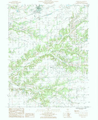
1985 Map of Brownstown
USGS Topo · Published 1985About this map
Brownstown serves as the primary hub in this mid-1980s landscape of Fayette County, where the transition from agricultural plains to wooded creek bottoms defines the local character. To the south, the settlement of Confidence sits nestled between various Oil Field operations, illustrating the persistent extraction economy of south-central Illinois. The map captures an intricate drainage network including Sandy Run and Walnut Creek, which carve through the townships of Sefton, Avena, and Wheatland. Genealogists and local historians can trace rural infrastructure such as Radio Towers and Sub Stations that supported the area's development. Significant water features like Gatch Lake and the winding course of Hickory Creek provide geographic anchors for researchers examining land use and property lines in Otego and Lone Grove townships during the late twentieth century.
Find a feature on this map
19 named features on this map. Tap any name to fly to it.
Don’t see what you’re looking for? This feature index may not catch every label — zoom into the map to look around manually.
Map Details
Editions of this 1985 Brownstown Map
This is the sole edition of this map. No revisions or reprints were ever made.
Other maps of this area

1941 · St. Elmo
USGS Topo · 1:62,500

1944 · Ramsey
USGS Topo · 1:62,500

1945 · St. Elmo
USGS Topo · 1:62,500

1945 · Kinmundy
USGS Topo · 1:62,500

1945 · Vandalia
USGS Topo · 1:62,500

1946 · Ramsey
USGS Topo · 1:62,500

1947 · Vandalia
USGS Topo · 1:62,500

1947 · Kinmundy
USGS Topo · 1:62,500

1958 · Decatur
USGS Topo · 1:250,000

1958 · Belleville
USGS Topo · 1:250,000