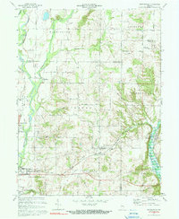
1972 Map of Brownsville
USGS Topo · Published 1973About this map
Whitewater River drainage patterns and rural crossroads define this 1970s landscape spanning the borders of Wayne, Fayette, and Union counties. The East Fork Whitewater River valley shows the early footprint of Brookville Lake, a significant hydrological feature affecting the local topography near Brownsville. Small, established communities like Philomath and Waterloo remain central to the area's geography, connected by a network of named thoroughfares such as Potter Shop Road and Philomath Road.
Find a feature on this map
43 named features on this map. Tap any name to fly to it.
Don’t see what you’re looking for? This feature index may not catch every label — zoom into the map to look around manually.
Map Details
Editions of this 1972 Brownsville Map
3 editions found
Other maps of this area

1915 · New Paris
USGS Topo · 1:48,000

1915 · College Corner
USGS Topo · 1:48,000

1918 · College Corner
USGS Topo · 1:62,500

1918 · New Paris
USGS Topo · 1:62,500

1948 · Fairfield
USGS Topo · 1:24,000

1953 · Cincinnati
USGS Topo · 1:250,000

1956 · Everton
USGS Topo · 1:24,000

1956 · Alpine
USGS Topo · 1:24,000

1956 · Brownsville
USGS Topo · 1:24,000

1956 · Connersville
USGS Topo · 1:24,000