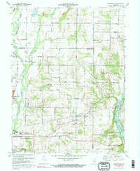
1972 Map of Brownsville
USGS Topo · Published 1973About this map
The Whitewater River cuts through this rural landscape on the border of Wayne, Union, and Fayette Counties, illustrating the historical layout of eastern Indiana before modern infrastructure expansion. The settlement of Brownsville serves as a focal point near the Brownsville Lake, where a notable Covered Bridge spans the water. The terrain is defined by its agricultural and communal foundations, evidenced by numerous small townships like Waterloo and Jennings. Local history is deeply embedded in the land through scattered landmarks such as Philomath Ch, the Township Sch, and several family and community burial grounds including Union Cem and Simpson Cem. The passage of the Baltimore and Ohio railroad and the network of numbered country roads like 400 North Road reveal the 20th-century transport patterns that connected these small farming communities.
Find a feature on this map
45 named features on this map. Tap any name to fly to it.
Don’t see what you’re looking for? This feature index may not catch every label — zoom into the map to look around manually.
Map Details
Editions of this 1972 Brownsville Map
3 editions found
Other maps of this area

1915 · New Paris
USGS Topo · 1:48,000

1915 · College Corner
USGS Topo · 1:48,000

1918 · College Corner
USGS Topo · 1:62,500

1918 · New Paris
USGS Topo · 1:62,500

1948 · Fairfield
USGS Topo · 1:24,000

1953 · Cincinnati
USGS Topo · 1:250,000

1956 · Everton
USGS Topo · 1:24,000

1956 · Alpine
USGS Topo · 1:24,000

1956 · Brownsville
USGS Topo · 1:24,000

1956 · Connersville
USGS Topo · 1:24,000