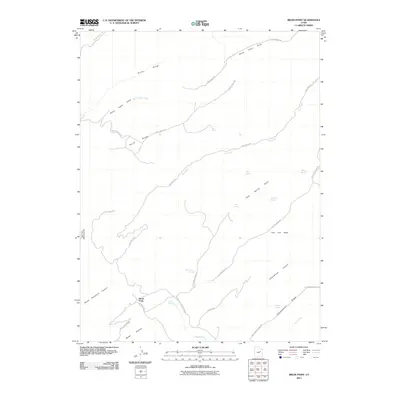
2011 Map of Bruin Point
USGS Topo · Published 2011About this map
Bruin Point stands as a prominent overlook in this high-altitude landscape of the West Tavaputs Plateau, where deep drainages like Cottonwood Canyon and Water Canyon carve into the elevated terrain. The road network, including Range Valley Mountain Rd and South Ridge Rd, traces the ridgelines to navigate between steep drop-offs and the isolated flats of Flat Iron Mesa. Numerous water sources, such as Burnt Cabin Spring, Tidwell Spring, and Maverick Spring, are critical landmarks in this arid environment, often marking the convergence of primitive tracks like Cold Spring Draw Rd. The presence of labels such as Stone Cabin Creek and Stone Cabin Draw suggests early ranching or pastoral activity in the northern reaches of the quadrangle. This 2011 survey documents a geography defined by its dramatic relief, where the few named routes must follow the natural contours of Horse Ridge and South Ridge.
Find a feature on this map
36 named features on this map. Tap any name to fly to it.
Don’t see what you’re looking for? This feature index may not catch every label — zoom into the map to look around manually.
Map Details
Editions of this 2011 Bruin Point Map
This is the sole edition of this map. No revisions or reprints were ever made.
Other maps of this area

1886 · Price River
USGS Topo · 1:250,000

1896 · Price River
USGS Topo · 1:250,000

1915 · Sunnyside
USGS Topo · 1:62,500

1954 · Flat Canyon
USGS Topo · 1:62,500

1956 · Price
USGS Topo · 1:250,000

1960 · Price
USGS Topo · 1:250,000

1962 · Price
USGS Topo · 1:250,000

1968 · Wood Canyon
USGS Topo · 1:24,000
1968 · Cowboy Bench
USGS Topo · 1:24,000
1968 · Currant Canyon
USGS Topo · 1:24,000