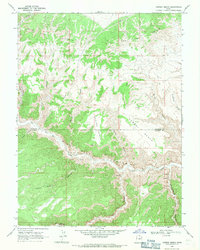
1968 Map of Cowboy Bench
USGS Topo · Published 1971About this map
Nine Mile Gas Field dominates the central canyon floor where the Duchesne and Carbon County line follows the winding path of Nine Mile Creek. This 1968 field check reveals a landscape deeply incised by erosion, featuring the prominent Cowboy Bench and Spring Bench plateaus elevated above the canyon systems. The presence of multiple petroglyphs and unique rock formations like The Mummy and The Alcove indicates a region of significant archaeological interest along the watercourses. Cultural imprints on this remote terrain are sparse but specific, ranging from the Nutters Corral to a modern pipeline and several gas wells, illustrating the transition from traditional ranching use to energy extraction. The northern horizon is defined by the sharp drop of the Bad Land Cliffs, while the southern reaches are marked by the steep drainages of Prickly Pear Canyon and Dry Canyon.
Find a feature on this map
24 named features on this map. Tap any name to fly to it.
Don’t see what you’re looking for? This feature index may not catch every label — zoom into the map to look around manually.
Map Details
Editions of this 1968 Cowboy Bench Map
This is the sole edition of this map. No revisions or reprints were ever made.
Other maps of this area

1886 · Price River
USGS Topo · 1:250,000

1896 · Price River
USGS Topo · 1:250,000

1915 · Sunnyside
USGS Topo · 1:62,500

1954 · Flat Canyon
USGS Topo · 1:62,500

1956 · Price
USGS Topo · 1:250,000

1960 · Price
USGS Topo · 1:250,000

1962 · Price
USGS Topo · 1:250,000
1965 · Wilkin Ridge
USGS Topo · 1:24,000
1968 · Anthro Mtn NE
USGS Topo · 1:24,000
1968 · Pinnacle Canyon
USGS Topo · 1:24,000