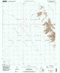
1996 Map of Bryan Mountains
USGS Topo · Published 2000About this map
The Bryan Mountains rise sharply between the desert floor of the San Cristobal Valley and the Mohawk Valley, defining a landscape of intense preservation and military utility. This 1996 survey illustrates the convergence of the Cabeza Prieta National Wildlife Refuge and the Cabeza Prieta Wilderness, showcasing the complex administrative boundaries that govern the southwestern Arizona desert. The map captures a moment when large swaths of the region were designated as the Barry M Goldwater Air Force Range, where access was restricted to facilitate defense operations within a fragile ecological corridor. The topographical detail reveals the isolated character of these peaks, which served as critical landmarks for travelers navigating the arid basins of the Yuma region.
Find a feature on this map
9 named features on this map. Tap any name to fly to it.
Don’t see what you’re looking for? This feature index may not catch every label — zoom into the map to look around manually.
Map Details
Editions of this 1996 Bryan Mountains Map
This is the sole edition of this map. No revisions or reprints were ever made.
Other maps of this area

1953 · Ajo
USGS Topo · 1:250,000

1957 · Ajo
USGS Topo · 1:250,000

1958 · Ajo
USGS Topo · 1:250,000

1962 · Ajo
USGS Topo · 1:250,000

1963 · Ajo
USGS Topo · 1:250,000

1965 · O'Neill Hills
USGS Topo · 1:62,500

1965 · Granite Mountains
USGS Topo · 1:62,500

1965 · Isla Pinta
USGS Topo · 1:62,500

1965 · Sierra Arida
USGS Topo · 1:62,500

1967 · Ajo
USGS Topo · 1:250,000