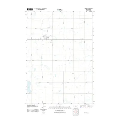
2012 Map of Bryant
USGS Topo · Published 2012About this map
Bryant serves as the focal point of this Hamlin County prairie landscape, organized around a traditional grid including Main Ave and Williams St. The town's community history is anchored by several distinct burial grounds on its outskirts, including Saint Marys Cem, Our Redeemer Cem, and Woodlawn Cem. Farther south, the solitary Clara Cem sits near 196th St, marking a quiet corner of the rural township. The surrounding terrain is defined by its glacial hydrology, where Johnsons Slough and the winding course of Dolph Cr dominate the central drainage. To the southwest, the large expanse of Plum Lake borders the section lines, illustrating the typical South Dakota landscape where agriculture and natural wetlands coexist. This survey provides a clear view of the section-line road network, such as Co Hwy M, which connects these remote settlements and farmsteads.
Find a feature on this map
28 named features on this map. Tap any name to fly to it.
Don’t see what you’re looking for? This feature index may not catch every label — zoom into the map to look around manually.
Map Details
Editions of this 2012 Bryant Map
This is the sole edition of this map. No revisions or reprints were ever made.
Other maps of this area

1899 · De Smet
USGS Topo · 1:125,000

1953 · Watertown
USGS Topo · 1:250,000

1958 · Watertown
USGS Topo · 1:250,000

1968 · Lake Preston NE
USGS Topo · 1:24,000

1968 · Erwin
USGS Topo · 1:24,000

1971 · De Smet
USGS Topo · 1:24,000

1973 · Bryant NE
USGS Topo · 1:24,000

1973 · Bryant
USGS Topo · 1:24,000
1973 · Gertson Slough
USGS Topo · 1:24,000

1973 · Vienna West
USGS Topo · 1:24,000