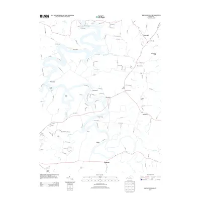
2013 Map of Bryantsville
USGS Topo · Published 2013About this map
Herrington Lake dominates the central landscape of this Kentucky quadrangle, where the winding water creates significant landforms like Brights Bend, Gwinn Island, and Dunn Island. The 2012–2013 settlement pattern reveals a cluster of small communities and crossroads that define the region's geography, including Bryantsville, Davistown, and Marcellus. These areas are connected by key crossings such as Kennedy Bridge and Chenault Bridge. The terrain is marked by distinctive elevations like Mount Hebron Ridge and Burdette Knob, which provide vertical contrast to the deep lake valleys. Further south, smaller hamlets like Little Needmore, Clifton, and Hedgeville are situated along tributary waters such as Clarks Run and Balls Br, illustrating a rural landscape where modern roads follow the logic of the local topography.
Find a feature on this map
122 named features on this map. Tap any name to fly to it.
Don’t see what you’re looking for? This feature index may not catch every label — zoom into the map to look around manually.
Map Details
Editions of this 2013 Bryantsville Map
This is the sole edition of this map. No revisions or reprints were ever made.
Other maps of this area

1905 · Harrodsburg
USGS Topo · 1:125,000

1950 · Bryantsville
USGS Topo · 1:24,000

1952 · Little Hickman
USGS Topo · 1:24,000

1952 · Buckeye
USGS Topo · 1:24,000

1952 · Danville
USGS Topo · 1:24,000

1952 · Harrodsburg
USGS Topo · 1:24,000

1952 · Lancaster
USGS Topo · 1:24,000

1952 · Bryantsville
USGS Topo · 1:24,000

1952 · Stanford
USGS Topo · 1:24,000
1952 · Wilmore
USGS Topo · 1:24,000