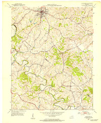
1952 Map of Lancaster
USGS Topo · Published 1953About this map
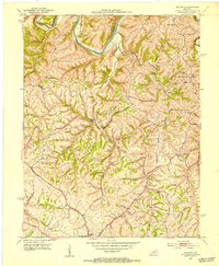
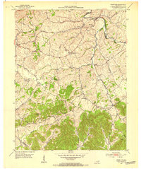
Lancaster serves as the hub of this Central Kentucky landscape, where the Louisville and Nashville railroad intersects with a road network that traces the ancient Wilderness Trail. The terrain is deeply dissected by the Dix River and its numerous tributaries, including White Oak Creek and Gilbert Creek, creating a complex series of ridges and hollows that define local settlement patterns. Rural life is anchored by small communities such as Preachersville and Hyattsville, along with landmarks of community importance like Gilberts Creek Ch and West Point Sch. Genealogists will find a wealth of specific data points, including several family or community burial grounds such as Ashlock Cem, Goshen Cem, and Payne Cem, which reflect the long-standing agricultural roots of both Garrard and Lincoln counties.
Find a feature on this map
30 named features on this map. Tap any name to fly to it.
Don’t see what you’re looking for? This feature index may not catch every label — zoom into the map to look around manually.
Map Details
Editions of this 1952 Lancaster Map
This is the sole edition of this map. No revisions or reprints were ever made.
Other maps of this area

1892 · Richmond
USGS Topo · 1:125,000

1893 · London
USGS Topo · 1:125,000

1897 · Richmond
USGS Topo · 1:125,000

1897 · London
USGS Topo · 1:125,000

1905 · Harrodsburg
USGS Topo · 1:125,000
1950 · Bryantsville
USGS Topo · 1:24,000
1952 · Halls Gap
USGS Topo · 1:24,000
1952 · Crab Orchard
USGS Topo · 1:24,000
1952 · Buckeye
USGS Topo · 1:24,000
1952 · Paint Lick
USGS Topo · 1:24,000