
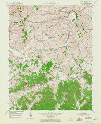
1952 Map of Paint Lick
USGS Topo · Published 1953About this map
Paint Lick Creek carves a winding path through this central Kentucky landscape, serving as a natural boundary between Garrard and Madison counties. In the early 1950s, the area was defined by a network of rural hamlets including Cartersville, Lowell, and Manse, each connected by narrow roads and family-centered landmarks. The presence of numerous small cemeteries such as Carpenter Cem, Robinson Cem, and Vanhook Cem suggests a deeply rooted local history, while schools like Oakdale Sch and Wrenview Sch illustrate the decentralized community life of the era. The terrain rises to distinct elevations at Button Lick Knob and Graveyard Hill, overlooking the intricate drainage systems of Drake Creek and Harmons Lick. This survey provides a clear view of the settlement patterns just before modern infrastructure reshaped the rural landscape, preserving the locations of country churches like Old Paint Lick Ch and Good Hope Ch.
Find a feature on this map
48 named features on this map. Tap any name to fly to it.
Don’t see what you’re looking for? This feature index may not catch every label — zoom into the map to look around manually.
Map Details
Editions of this 1952 Paint Lick Map
2 editions found
Other maps of this area

1892 · Richmond
USGS Topo · 1:125,000

1893 · London
USGS Topo · 1:125,000

1897 · Richmond
USGS Topo · 1:125,000

1897 · London
USGS Topo · 1:125,000

1905 · Harrodsburg
USGS Topo · 1:125,000

1952 · Berea
USGS Topo · 1:24,000

1952 · Crab Orchard
USGS Topo · 1:24,000

1952 · Buckeye
USGS Topo · 1:24,000

1952 · Lancaster
USGS Topo · 1:24,000

1952 · Kirksville
USGS Topo · 1:24,000