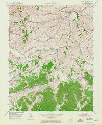
1952 Map of Paint Lick
USGS Topo · Published 1971About this map
The borderlands of Garrard, Madison, and Lincoln Counties are defined by the convergence of several waterways, most notably Paint Lick Creek and its various forks and branches. At the time of this 1950s survey, the landscape was dotted with tight-knit rural communities such as Paint Lick, Cartersville, and Lowell. The density of named family cemeteries, including the Carpenter, Vanhook, and Robinson plots, suggests a deeply rooted local genealogy across the rolling terrain.
Find a feature on this map
48 named features on this map. Tap any name to fly to it.
Don’t see what you’re looking for? This feature index may not catch every label — zoom into the map to look around manually.
Map Details
Editions of this 1952 Paint Lick Map
2 editions found
Other maps of this area

1892 · Richmond
USGS Topo · 1:125,000

1893 · London
USGS Topo · 1:125,000

1897 · Richmond
USGS Topo · 1:125,000

1897 · London
USGS Topo · 1:125,000

1905 · Harrodsburg
USGS Topo · 1:125,000

1952 · Berea
USGS Topo · 1:24,000

1952 · Crab Orchard
USGS Topo · 1:24,000

1952 · Buckeye
USGS Topo · 1:24,000

1952 · Paint Lick
USGS Topo · 1:24,000

1952 · Lancaster
USGS Topo · 1:24,000